
Developing a GIS – based decision support tool to identify suitable areas for siting a solar park: The case study of Limassol district in Cyprus
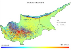
Among the renewable powers sources, solar is rapidly becoming popular being inexhaustible, clean, and dependable. It is also becoming more efficient since the photovoltaic solar cells’ power conversion efficiency is rising. Following these trends, solar power will become more affordable in years to come and considerable investments are to be expected. Sitting solar plants is a crucial factor for their efficiency and financial viability. This paper describes an integrated framework to evaluate land suitability for the optimal placement of photovoltaic solar power plants, which is based on the combination of a Geographic Information System (GIS) and multi-criteria decision making methods. An application of the proposed framework for Limassol District in Cyprus is further illustrated. The combination of GIS and multi-criteria methods, consist an excellent analysis tool that creates an extensive database of spatial and non spatial data that will be used to simplify problems, to solve and promote the use of multiple criteria. A set of environmental, economic, social and technical constrains based on recent Cypriot legislation, identifies the potential sites for solar park installation. The pair-wise comparison method in the context of the analytic hierarchy process (AHP) is applied to estimate the criteria weights in order to establish their relative importance in site evaluation. Four different methods to combine information layers were used. The first considered all the criteria as being equally important and gave them equal weight, while the others grouped the criteria and graded them according to perceived importance. The overall suitability of the study region for siting solar park is appraised through the summation rule. Resulting maps may be used for finding best possible areas using threshold or for selecting best areas based on the financial investment.
The project has been presented in Symposium RSCY 2014, see publications
All images are copyrighted(c)2014 Dimitrios Skarlatos, Andreas Georgiou
The project has been presented in Symposium RSCY 2014, see publications
All images are copyrighted(c)2014 Dimitrios Skarlatos, Andreas Georgiou
