
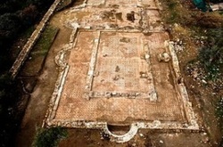
Mapping the mosaics and the surrounding area on a Proto-Byzantine monument at Akrotiri Peninsula
Following a co operation with Department of Antiquities and the Sovereign Base Areas (SBA), flights with the UAV over the archaeological site and the cliffs, have taken place. The flight height was at about 260m and the pixel size 0.10 m. Control points were collected using dual frequency GPS on RTK mode.
The photos collected were processed to create a 1:1000 scale orthophoto, with high quality, over an 1 square kilometre area. Dense DTM and contours were a by product of the process.
Two diploma thesis have been assigned to create a high detail map of the monument itself and high resolution (1mm) orthophotomaps of the magnificent mosaics of the monument.
This research is based on and extends Cyprus University of Technology starting grant "Videometry from mobile platforms"
More info about the archaeological site.
Orthophotos of Mosaics
The temple has excellent mosaics. In order to document them close range photos were needed. The time needed for the excavation team to reveal all the mosaics for the aerial photography took most of the excavation period, hence adequate time should also provided for covering them appropriately within the already limited excavation period. Therefore a cheap and fast way for docymentation was selected. Hand held photography for all the mosaics. In total 950 photos from 1.3 meters approximately were taken. C. Christoforou doing his diploma thesis has done the processing, including georeferencing using control points (measured by laser theodolite) and computer vision software with bundle adjustment, DTM and ortho creation features. Finally all images were orthorectified into orthomosaics. The final pixel size is 0.001m. The final orthos were very large files, hence the area was divided in 17 orthophotomosaics.
